"My experience with the work that has been done on my projects has been great - easy to work with, quick on the turn-around, and a high quality product."
Envirosolve Corporation, Project Manager, CA
LOGitEASY provides a pay-as-you-go online service (Premium Logs) for creating report-quality boring logs. The service includes use of the LOGitEASY eForm, a web-enabled data entry form that looks like a paper field logging form, and a choice of LOGitEASY, gINT, and LogPlot templates.
We created the Premium Logs service for those geotechnical and environmental consultants that use gINT or LogPlot or require more advanced logging functionality and/or a greater selection of templates than in our Free Logs service. Premium Logs integrates a field logging solution with gINT, LogPlot, or other boring log software. We selected pay-as-you-go pricing for LOGitEASY’s Premium Logs service so that Project Managers could use it on a project-by-project basis, without having to secure company approval to purchase software. It is possible to upgrade from Free Logs to Premium Logs service within each individual eForm if in the course of the project the need arises for Premium Logs functionality.

How it Works
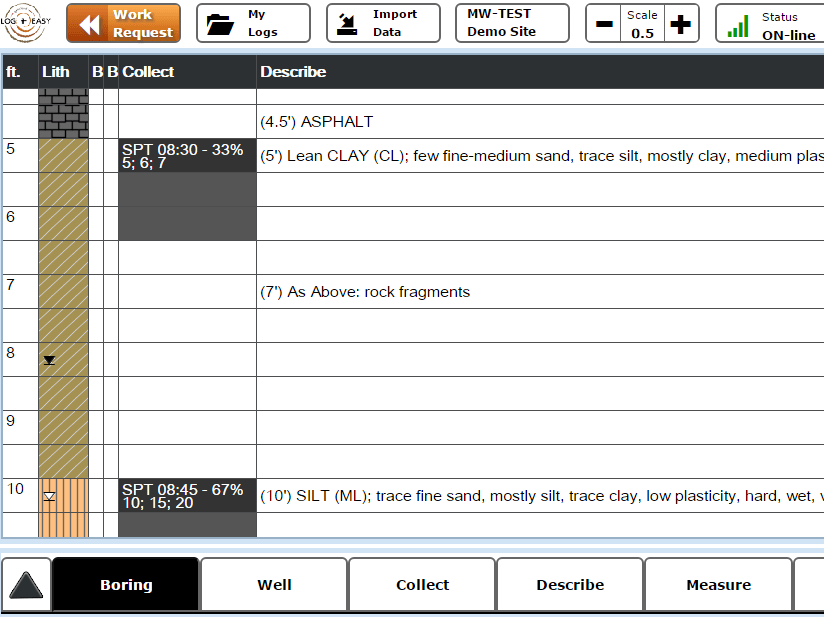
Premium Logs service, like Free Logs, requires users to first Sign Up free to get access to the LOGitEASY Workspace (website) where the LOGitEASY eForm resides and where logs are generated. Once users log in, they open a LOGitEASY eForm for each of their borings/wells (can also be used for test pits, probes, or remediation wells) and begin entering data into the forms. The eForm serves both as a field logging form and as boring log software, which means that users can enter data directly into the form during drilling or from their field notes after drilling. The eForm is accessible from any location where there is an internet connection, but it is also possible to use the LOGitEASY eForm without an internet connection, if working in the field in remote locations or without a data plan.
Once data has been entered and saved to the cloud, users can instantly generate logs in LOGitEASY templates or receive logs in 3 or 7 days in gINT or LogPlot templates. A digital data file (.xls, .gpj, or .dat) and legend are included with the logs as part of this service.
Premium Logs Advanced Functionality
Premium Logs includes the following advanced functionality not included in Free Logs service:
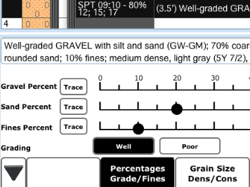
- Pro Soil Logging Functionality – This feature allows users to create soil descriptions according to the ASTM Visual-Manual Procedure, by first entering the percentages of gravel, sand, and fines to determine the soil’s group name and symbol. The core of this feature is the USCS Calculator which is also available as a free tool on this website.
- Nested Well Functionality – This feature allows users to enter well construction data for a second and third well (nested wells) installed in a boring. There are nested well templates for LOGitEASY, gINT, and LogPlot logs.
- Munsell Color Calculator – This feature allows users to enter the Munsell color code when describing soil/rock samples, and converts this code into the Munsell color name which is then included with the code in the soil/rock description. The Munsell Color Calculator is also available as a free tool on this website.
- Rock Classification – This feature allows users to classify rock in detail using a series of automated menus containing descriptor fields and labelled option buttons (as with soil descriptions). This ensures rock descriptions that are complete and consistent, and entered in the most efficient way possible.
- Fracture Description – This feature allows users to describe fractures in detail in terms of type, measurements, surface, and filling. Fracture data is reported on the Geotechnical template logs.
- Frozen Soil Classification – This feature allows users to classify frozen soils (Alaska) using a series of menus similar to those used for soil descriptions. Frozen soil functionality can be hidden if drilling through non-frozen soil.
- Data Import from Other Logs – This feature allows users to import data from a previously-created LOGitEASY boring log into the currently-opened eForm. This feature can be useful in cases where the installation of a well or drilling of a deeper boring is proposed adjacent to an existing boring, without stopping for sampling in the previously-sampled interval.
Premium Logs Templates and Data Files
In addition to the LOGitEASY Environmental and Geotechnical boring and well log templates available as part of Free Logs service, users can also choose from gINT and LogPlot Environmental and Geotechnical boring and well log templates. If you are using gINT or LogPlot and have a specific data structure and/or template for which you would to integrate LOGitEASY’s field logging solution, please contact us. It is also possible to receive just an .xls data file of digitally entered field data for use in your gINT, LogPlot, or other boring log software.
View Boreholes on Aerial Map
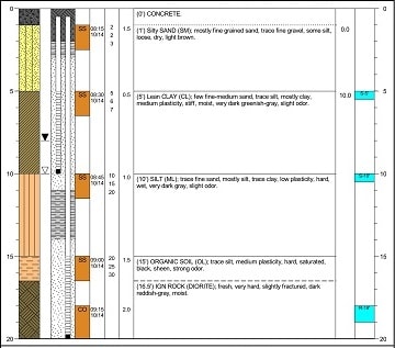
Once the soil is logged using the LOGitEASY eForm and boring logs finalized, borehole locations can be viewed on a geographic map (provided LAT and LONG coordinates are entered for the logs).
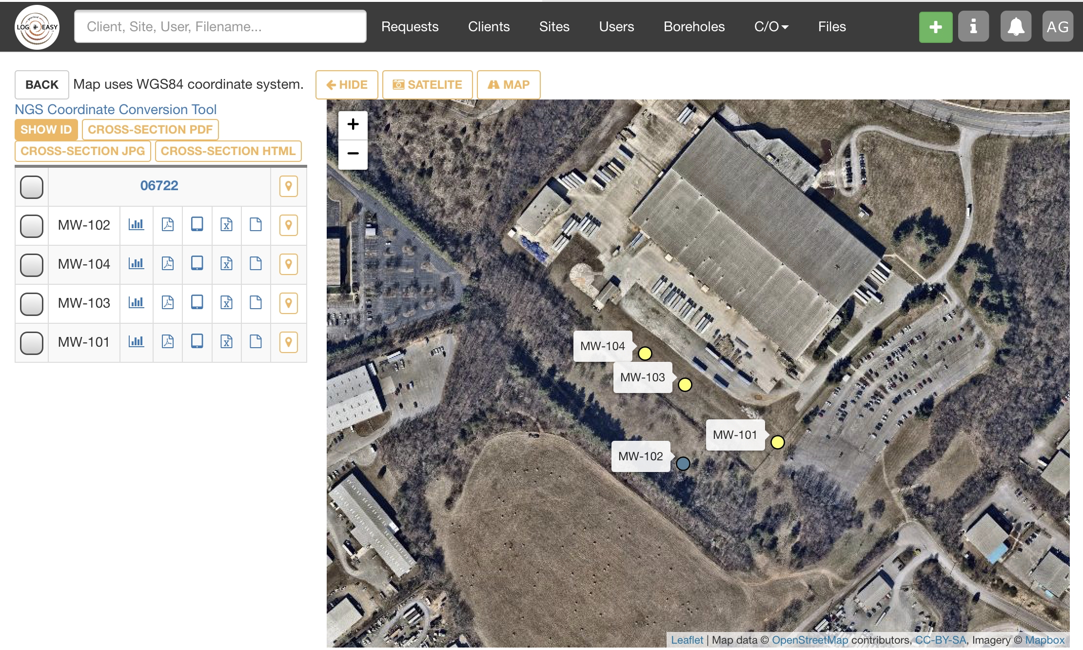
Predict Local Geology
Compare lithology to other/historical borings in the vicinity, download PDF and Excel/gINT/LogPlot data files, access field logging eForm. View soil borings and monitoring wells side by side using Borehole Report Map. Good way to visualize lithology of multiple borings/help in creating cross sections.
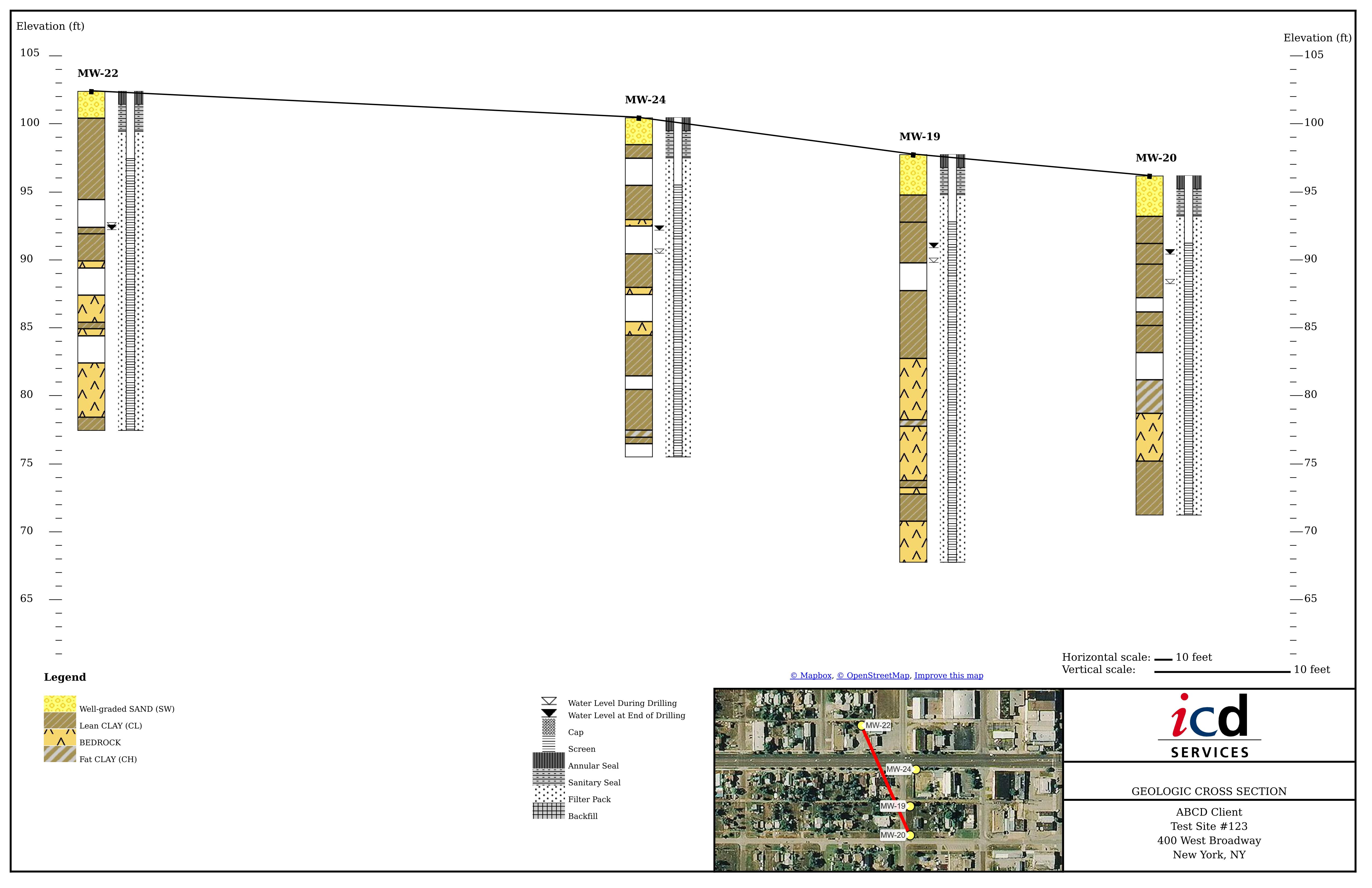
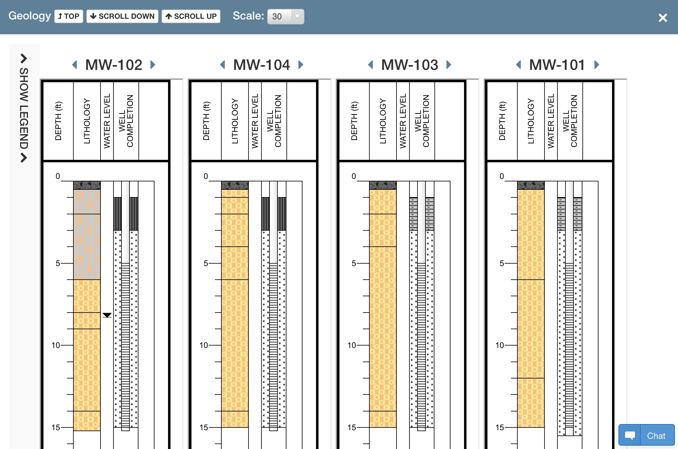
Create Geologic Cross Sections Online
LOGitEASY Premium Logs service (both Pay-As-You-Go Plan and All-You-Can-Log Subscription) allows generating instant Geologic Cross Sections from the boreholes logged using the eForm. Cross Sections include lithology, boring/well construction graphics, groundwater and ground surface elevations, company logo, titleblock, site address, and aerial image with cross section line:
- Log Field Data Using LOGitEASY eForm
- Create Boring Logs Instantly
- Select Borings/Wells from a List or Map
- Generate Geologic Cross Section Online